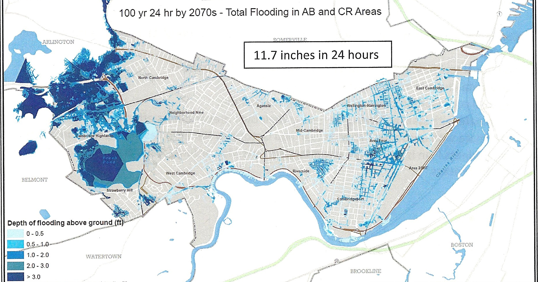
100-year storm projected flooding in 2070
The Fresh Pond/Alewife area has always been vulnerable to flooding, even without the looming threat of rising sea levels and increased precipitation predicted with climate change. As our area comes under intense development pressure, the FPRA is concerned with how to design new buildings and retrofit established neighborhoods to withstand periodic flooding and how to protect sensitive areas like Fresh Pond Reservoir (the city’s water supply) and the Alewife Reservation (a protected wetland habitat) from increased, polluted stormwater runoff. For over two years the city has been preparing a Climate Change Vulnerability Assessment that will inform new planning and building regulations as well as emergency response measures. The interim results will be presented on Tuesday, March 17 at 6:00 pm (NEW DATE) at MIT in the Stata Canter’s Kirsch Auditorium.. And, if you think a warming climate will mean fewer massive snowfalls like this, read this article on research by an MIT climate scientist.
Please use comments section to add your questions to the ones below:
- When will a full written report be available for review by residents? What is the timeline for developing the plan and necessary regulatory changes resulting from the Assessment?
- If the two River dams will protect Cambridge until 2030 (assuming working pumps at the Amelia Earhart Dam) what about after 2030? That is only 15 years away, a short-term planning horizon. New buildings or substantial improvements on the drawing board now will be built by then and subject to the risk of flooding. Presumably flood-related specifications are intended to protect buildings and people for the life of the buildings, not just their first few years. Will Cambridge’s regulations and codes be written for the higher level of risks anticipated in the next 50-100 years?
- Many Cambridge residents are knowledgeable about engineering and environmental studies; we would benefit from understanding the data behind the study’s conclusions. Will the Woods Hole Oceanographic Institution (WHOI) issue a complete report including the details of its study, and if so, when?
- Will those who did the research for the report—the paid experts in surge and other elements of climate impact—be available for questions from residents?
- Will some measure of water height be marked visibly on an easily accessible City structure (e.g., the Cambridge Water Dept. building at Fresh Pond) for a visible reference of 500-year (or other reference year) flooding?
- How will evacuation routes be identified and coordinated with neighboring cities and towns? East Arlington is also vulnerable to flooding.
- What flood levels would interrupt each critical service: Red Line, commuter rail, intersection signal lights (DCR, Mass DOT, Cambridge), electricity, water (especially firefighting pressure), sewer, land line telephone, hospital, school (unrecoverable within a week), elevator systems with equipment at the lowest level? How will that change over time (by 2030, 2050)?
- Is there a recovery plan and an estimate of how long it would take to restore public infrastructure after a catastrophic storm like Sandy, which struck NYC in 2013? (See http://www.nyc.gov/html/recovery/downloads/pdf/sandy_aar_5.2.13.pdf)
- Is there a flood or surge level that would interrupt the fresh water supply from Fresh Pond for a number of months and require extended supply from the Massachusetts Water Resources Authority (MWRA)?
- Based upon the implications of the vulnerability study, is the US Army Corps of Engineers (USACE) evacuation map suitable for Cambridge? (The USACE evacuation map can be found on the Cambridge vulnerability study page, or: http://www.mass.gov/eopss/agencies/mema/hurricane-inundation-maps.html
- What kinds of pollutants would be likely to be released from flooding at the current 500-year flood level? What kinds of damage would result?
100-year storm projected flooding in 2070
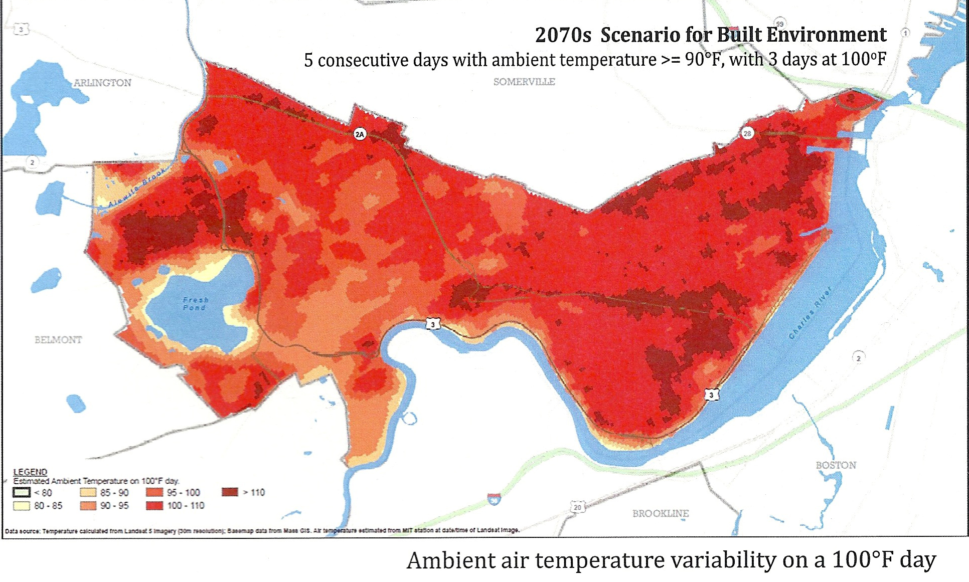
Projected urban heat island effect in 2070
