Questions about the impact of development on the Alewife flood plain and about how planning for climate change will necessitate new flood mitigation and storm water management measures prompted a group of FPRA members to research and write the following report. Thank you to Peggy Barnes Lenart, Arthur Strang, Jay Yesselman, Mike Nakagawa, Alison Field-Juma, and Alice Heller for taking the initiative to form a working group, and to Owen O’Riordan, Cambridge DPW Commissioner, and Kathy Watkins, Cambridge City Engineer, for meeting with the group and sharing their knowledge.
We all know that the Fresh Pond/Alewife area (FP/A) has a naturally soggy history. We wanted to understand what we can do now so that the future—which will include a lot more people and assets—will avoid the worst effects of flooding. Below is a summary of what we learned through our own research and a presentation to us by Owen and Kathy. This is just a summary—ask us questions and we’ll seek to answer them!
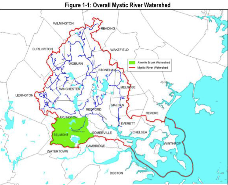
We looked at two threats: The rain/snow that falls from the sky and collects in the FP/A area on its way to Alewife Brook and the Mystic River; the sea and river water that may surge upstream in a major storm and reach Alewife raising the flood level there. We are in the Mystic River watershed and the Alewife Brook sub-watershed. The Alewife Brook sub-watershed is 8.5 square miles and includes Cambridge, Belmont and Arlington (and a bit of Somerville, downstream). The Mystic River Watershed is 76 square miles, encompassing 21 communities including Woburn, Winchester, Lexington, Melrose, Malden, Everett and Chelsea.
A. Falling Water (rain/snow that falls in the Alewife sub-watershed
1. The Alewife 100-year flood plain is defined by the FEMA maps of 2010 based on the Cornell 2003 precipitation data. The 100-year floodplain is the area that would be under water from a river overtopping its banks after the amount of rainfall in a 24-hour period that has a 1% chance of happening in any given year. That can be viewed as a storm expected to happen about once in 100 years, but it could happen more than once a century, or even decade, or possibly even a year. Another view is that over the course of a 30-year mortgage, there is a one-in-four chance of the flood occurring. The Triangle is in the 100-year floodplain (1% chance storm), much of the Quadrangle and up Concord Ave. is in the 500-year floodplain (0.2% chance). Actual flooding levels will change due to climate change, but the FEMA maps are based on models using actual, historical data at the time of the flood study.
2. There is high groundwater in the Alewife area, just 2-4 feet below the ground surface; the ability to infiltrate stormwater into the ground is very limited. Infiltration within the Alewife area helps to clean pollutants out of runoff from small storms, but does not prevent flooding within the area. The current floodplain maps include only Alewife and small sections of East Cambridge as being the severely flood-prone areas in the city. However, other areas of the City, such as Area 4 (Cherry Street, Pine Street areas) Cardinal Medeiros, and the Agassiz neighborhood are regularly impacted by stormwater due to capacity constraints in the sewer and drainage systems. The flooding in these areas is not directly associated with river flooding, so it is not shown on the FEMA floodplain maps.
3. There is a “bottleneck” in draining floodwaters from Alewife. The water flowing downstream from the FP/A area joins the larger Mystic River as it flows towards the Amelia Earhart Dam. The flow from the Alewife Brook slows at this junction, causing a rise in floodwater elevation in the brook.
4. Data show increasing intensity of precipitation over the last 50 years—more intense rainfall means less soaking into the ground and more runoff. This trend is expected to continue. In the upper FP/A catchment, in neighborhoods around Fresh Pond, flooding is caused by falling water not being able to drain away quickly enough due to the flat topography and high water table. Additionally, impervious surfaces, such as pavement and buildings, limit the absorption of rainwater and can increase runoff. No storm drain system in this area can convey the stormwater quickly enough due to inadequate slope. As a result it will temporarily back up, and streets with high curbs (6-inch) are one place stormwater is stored by design. It is difficult and expensive to store stormwater underground in these neighborhoods. People with driveways below street level will funnel water into their garages and basements, and apartments/living spaces in basements should be avoided. The water table around Fresh Pond is intentionally kept high to keep polluted groundwater out of the Reservoir.
5. The rules: Cambridge has no municipal wetlands bylaw. Hence, the main regulation affecting development in the floodplain is the Mass. Wetlands Protection Act which requires the Cambridge Conservation Commission to review projects in the 100-year flood plain and issue conditions to build. It may deny projects, and their decisions may be appealed to Mass. DEP. Developments must provide 1:1 compensatory storage for 100-year storms (you fill 100 square feet, you provide 100 sf elsewhere on site at the same elevation as the fill, connected to the floodplain). Underground areaways and parking of the new buildings can be designed to store floodwater. Peak discharge from the site cannot be increased for storms ranging from the 2-year to the 100-year storm. The sizing of storm drain infrastructure to achieve this is based on the 1961 standards but it is the change in runoff that matters not the absolute amount. Result: developments in the Triangle and Quadrangle should have little or no effect on flood levels up to the 100-year storm if properly built. However, there are no requirements for runoff or storage beyond a 100-year storm. Development within the 500-year floodplain is not regulated. That is true both for the higher elevation of buildings located in the 100-year floodplain, as well as buildings located only in the 500-year floodplain.
6. Conditions set citywide by statute have been more durable than state rules. E.g., new Stormwater Management Guidelines put in place following the 2006 Concord-Alewife Study and rezoning require that runoff from the 25-year post development storm must be less than or equal to the runoff from the 2-year pre-development storm. This is accomplished by storage tanks, swales/raingardens, green roofs, etc. The City currently makes no additional requirements for flood storage.
B. Rising Water (storm-driven high tides and sea level rise)
1. With climate change, the Mystic River may back up and the ocean may top the Amelia Earhart Dam on the River, further aggravating the back-up or even adding water to it. Nor’easters last longer than hurricanes and are more likely to cause flooding problems in Alewife due to ocean storm surges.
2. We are awaiting the results of the Cambridge Climate Change Vulnerability Assessment to see exactly where this is predicted to happen. See: http://bit.ly/1wKdSM3. The City will prepare a climate change adaptation/resilience plan based on the Assessment, including changing regulations and codes, starting in early 2015. Woods Hole Oceanographic Institute and Mass Department of Transportation are modeling the North Atlantic Ocean; their results will be used to understand the impacts of sea level rise and coastal flooding, particularly as it relates to the function of the Amelia Earhart and Charles River dams. Concurrently, the City is conducting extensive modeling to evaluate how the City’s storm drain system will perform. The results will be presented to the public in January 2015—all are encouraged to attend.
3. Preliminary precipitation calculations incorporating climate change indicate that the current 500-year floodplain in the FP/A area may become the 100-year floodplain by 2070 mainly due to the confluence of sea level rise and increasing precipitation intensity.
C. A note on sewer separation:
The combined sewer overflow (CSO) to Little River/Alewife Brook was 50 million gallons of untreated sewage per year; that has been reduced currently to 25 mg, and when the on-going separation in the Fresh Pond area is complete it will be 7.8 mg. The newly diverted stormwater from the Fresh Pond area will be discharged through into the treatment wetland at Alewife. CSOs from areas outside of the Fresh Pond area will still occur, but much less frequently. The interceptors at the river/brook are owned by the MWRA, transporting the sewage to Deer Island. All the feeder lines are owned by the City. The City went significantly beyond what the EPA required in designing and building the sewer separation projects now underway. The City has incorporated stormwater storage at New Street and Bellis Circle in the design and also has a concept to include storage at the Tobin School in conjunction with school reconstruction.
D. Implications for development in the FP/A area
1. Buildings built sufficiently above ground level using appropriate construction methods will be protected from substantial floods, even in the floodplain. No living space is allowed below the 100-year floodplain elevation in the floodplain. Many developers have chosen to elevate buildings above the floodplain elevation, which the city encourages. .The buildings will, therefore, be protected from flooding, but not necessarily the people or their vehicles.
2. Since the FP/A are is already largely impervious from previous development, new building in the floodplain should not aggravate the flood risk to existing ground-level buildings (at least up to the 100-year storm), since new structures are not allowed to displace floodwater. Development won’t make it worse for existing structures, nor will it make it better. However, displacement of volume storage beyond a 100-year storm is unregulated.
3. The main flood risk for most of the established neighborhoods around Fresh Pond is from inability to drain local precipitation, not from Alewife area flooding closer to Alewife Brook (as noted above).
E. Actions
1. Aim to “Bend Not Break” with the anticipated climate changes. The City needs to find more ways to filter, store, and drain water away safely from major storm events.
2. Attend upcoming city meetings on the Climate Change Vulnerability Assessment, and then ensure that the zoning and policy changes needed to respond to climate vulnerability are put in place. Once the Assessment is released, the City’s next steps are to:
- look at probability of flood impact on various city assets, e.g., NSTAR, transportation, hospitals, private and public structures, telecommunication
- prioritize high-risk entities
- adopt measures to mitigate and create resiliency to flooding.
3. Focus on at least taking the “No Regrets” Actions ASAP:
- Provide guidance to homeowners on how to protect their homes better—a “resiliency audit”—and provide grants for audits and actions by home and small business owners
- Pass a Watershed Bylaw drawing from relevant provisions of wetlands bylaws adopted by other communities, etc. For example, Arlington’s Wetlands Bylaw requires 2:1 wetlands replication and 2:1 floodwater compensatory storage whereas the Mass. Wetlands Protection Act requires only 1:1. The bylaw also requires that cumulative effects of development be considered, and regulates upland areas adjacent to wetlands/floodplains.
4. Other design changes to press for are: zoning changes, add flood storage, add berms to maintain access during flooding, green space, mechanicals on roofs, higher elevations of buildings, green roofs, raised pedestrian/bikeways (see Urban Land Institute’s Living with Water report, 2014). The amount of vegetation/green space and number of trees within the FP/A area should be increased to reduce the impacts of smaller storms through removing pollutants from stormwater and evapotranspiration, respectively.
5. Work to change the state Building Code to respond to new needs.
6. Press for assessment of emergency services during Alewife flooding.
7. Raise awareness and cooperation within the city and across surrounding towns’ residents, governments, activists and institutions to address the shared issue of flood risk and resiliency.
8. Aim to have an annual or biennial review of new information and actions needed to reduce flood risk (regulatory, physical, organization, etc.) established by the City with full community participation.
9. Support City efforts to improve Cambridge’s Community Rating Score for floodplain management exceeding the National Flood Insurance Program’s minimum standards. The City’s goal is to meet the level which would provide a 10% reduction in insurance rates.

Thanks for laying out some of the floodplain history and WPA needs for Cambridge, Those of us with the Friends of Alewife have had 4 major forums on this issue at Lesley and in Belmont, and would like to be involved in this group, as we have desired a Committee for a long time. We have the universities’ attention and have the floodplain maps made by a GIS specialist from MIT which we gave to all of our representative legislatures in 2011, and have made the cause known far and wide and would appreciate the inclusion to search for solutions with North Cambridge residents.
We continue to monitor, collect the water quality samples keep a regular album of our work findings, teach classes and bring out university groups, and share it with the broader public. Hope this is not an elite effort but one for seeking solutions with grounded and well researched individuals, most from the same neighborhood.
We (FAR) are working with Belmont to get their attention as well and are following their storm water litigation. Alice Heller represent FPRA on our Silver Maple Forest Alliance Board made up of various organizations. Presently, the Alliance is working very hard to retain the former forest land as conservation floodplain land and to prevent tens of thousands of gallons of polluted storm water from the pending building to go into Cambridge wetlands. We have a recent hydrology study showing this. The recent Environmental Committee Hearing by leland Cheung brought all of these out with 5 slide shows: http://www.friendsofalewifereservation.org.
We hope to keep the local politics at a minimum and look at facts, figures, history, etc.
There are some errors in the blog, but will respond later on that. The blog finally uses the correct language
of watershed, and seems to want to move forward.
To move forward the by-laws that it refers to must be adopted.
The Federal Court Order against Cambridge to proceed expeditiously with the sewer/storm water separation by 2015 ending is a grand opportunity to improve the regulations and to continue to reach as FAR has planned, to improve watershed flood retention, by preserving the floodplain parameters made up of natural resources.
I personally have gone through to heads of COnservation Commission with that issue, coming very very close to adoption. There was a pamphlet within days of being produced on recently designated wetlands of the city, which was discarded just before publication date. Then the next
Ex. Dir. also had this initiative removed just before the time of adoption amongst the Commissioners.
Thanks for doing this.
Ellen
LikeLike
After a quick read–fabulous. Thank you so much for doing this work.
Andrea
LikeLike
Much testimony resounds about the outdated precipitation data. Use this report http://friendsofalewifereservation.org/SMF-2014-10-08-Bruce-Jacobs-reformat-J413%20drainage-calcs-review-report-1.pdf for present data. There is a 67 percent increase between 2006-2011 which most states along eastern seaboard are using the latest data. Ma. is not because of the terror of increased flood insurance if they do. But endangering lives not to. So please correct the Blog and use the recent data. We will be trying to force (persuade) the city to upgrade its storm water regulations and create a by-law as well as other cities and towns are doing in Mass.
We are very far behind in these endeavors. And the 4 time delay in the Vulnerability Study allowed
the forest to be removed- Cambridge’s only forest, and a floodplain one at that.
Ellen
How could we??
LikeLike
There is a lot of serious work that has gone into this by the group. As many of you know , BSC has done all of the flood plain engineering at Cambridge Discovery Park as well as my own developments on Cambridge Park Drive . They have also met several times with smaller groups from the FPRA. Please let me know if you would like me to ask them to also look at this work for you. I know they would like to continue the relationship with you.
LikeLike
Thank you, Rich. One of the “flood group” will be in touch with you.
LikeLike
Look forward to that ; David and Ingeborg are standing by and looking at this work already.
LikeLike
Pingback: Climate Change Report Could Change Future Alewife Development | Go Boston Apartments
Friends of Alewife Reservation is grateful to Belmont’s major thrust forward for improved watershed conditions in the CSO and storm water field and needs to be followed downstream by neighboring city of Cambridge, including by developers who are over-building on the floodplain:
See recent storm water by-law of Belmont and budget.
https://mail.google.com/mail/u/0/#search/stephanie/15b8d19666cc4945?projector=1
By noting our Little River neighbor’s new improved policy, it gives Cambridge HOPE for
future improvements. TAKE NOTE OF BELMONT!!! We now have a model to follow.
Thanks Cambridge Committees for taking note.
LikeLike