UPDATE: The Cambridge Planning Board’s continued public hearing on this project has been scheduled for Tuesday, April 4, 8 pm, at City Hall Annex, 344 Broadway (corner of Inman).
The Fresh Pond Residents Alliance provided these written comments to the Cambridge Planning Board on the proposed new residential development of 320 units at the Lanes & Games/Gateway Inn property on March 4, 2017. The first Planning Board Hearing was held on February 21, 2017, and was continued to an undefined date. Application documents are available here.
FPRA has serious concerns regarding this project. It is a redevelopment of a currently low-density commercial site that is not only within the current 100-year flood delineation but within the floodway itself. It is in the worst part of the whole Alewife area in terms of flooding. The City’s climate change vulnerability assessment shows that this site will be the most affected of any site in the Alewife area. In the application, BSC notes 2030 100-year elevation as 7.46 NAVD. It appears that Flood Elevations associated with the 2030 and 2070 100-year storm events have been provided by the City to the Applicant but not to the Planning Board. From the information available, we conclude that there will be significant flooding every five years, on average. We support Mr. Russell’s request to see the actual flood levels expected at the development site with information on where the flood waters will come from. This should be for current, 2030 and 2070 timeframes. Our specific concerns are as follows:
- The project is presented with no context information from the applicant or CDD. We believe it is only by seeing the cumulative effect of each project that the Planning Board can properly assess the impacts. The Alewife area is developing extremely rapidly and has many serious problems, including traffic, mobility and lack of infrastructure. It is not possible to assess the incremental negative effects, and their relative importance, without this context. The CDDE or applicant should provide: current and planned development changes in population, population of children, affordable housing units, percent open space (green and publicly accessible, and housing turnover rates—especially of rentals in this area. The CDD should show the cumulative effect of each project on transportation and circulation , additions to the housing stock, implications for public services, and usable open space for the entire area.
- Housing is not an acceptable use of this site because it:
- Puts people in harm’s way due to the extreme flooding it will experience. It would be inaccessible to Cambridge fire trucks, ambulances, and other emergency services during flood events. These conditions would place people at serious risk. The DPW memo of 2/15/17 asserts that the building has been designed “to minimize damage and recover from the 2070 100-year flood event,” but this logic does not apply to the people living within it.
- Residents who are low to moderate income have fewer financial resources to draw on for weathering flood conditions and property damage (e.g., loss of vehicle) and to relocate when the area floods or afterward. The people selected for affordable units don’t have the same options for balancing the risk of living in the worst part of the flood zone as people with financial means. If they are selected for a unit, they will jump at the opportunity compared to the possibility of being flooded and the potential danger. But some people will be on the wrong side of the gamble. The market-rate housing will be primarily transient wealthier people who can exercise options, such as leaving the area for higher ground in a hotel. They may have family nearby, which is less likely for immigrant families. This is a problem of environmental justice.
- The area is jammed by failing traffic intersections during rush hours. How would school buses access the site for the children living there? Out of 320 units, how many would have children? The sidewalks being provided along the Rte. 2 highway have no protection from speeding cars—wouldn’t children be walking here?
- Parked cars that are in the floodplain would be irreparably damaged and would pollute the adjacent wetlands, waterways and Alewife Brook/Mystic River.
- What kind of housing is being provided? The rental turnover rate is this area is very high, with tenants staying less than a year. One of the main predictors for resiliency in the face of weather extremes is community cohesion. Placing an essentially transient population in this zone would be unwise.
- The air pollution from being so close to a high volume roadway that is heavily congested for much of the day would be a health hazard for people living there. It would be inadvisable for the low-income housing families to have their kids play outside. Small particulates (PM10, PM5, PM2.5) are particularly harmful.
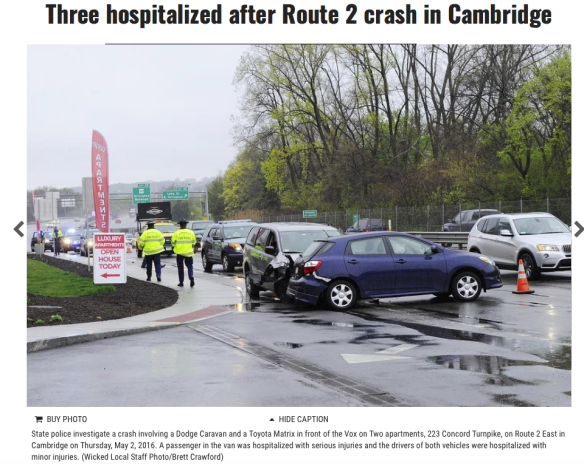
- Traffic—Project Review Special Permit (Section 19.20). This project will have “a substantial adverse impact on city traffic within the study area.” The project would make traffic incrementally worse by some 840 daily vehicle trips (according to the Traffic Impact Study (TIS)), in addition to the cars from Vox on 2, and from Cambridgepark Drive. The traffic presentation should include all traffic down thought the Fresh Pond rotary and the dates of the study’s data collection. We ask that traffic studies include measurement of peak traffic on peak days (non-school holiday, non-summer) of the year, not just peak hours. Up to the sites containing Vox on 2 and the proposed project, Route 2 is a limited-access 3-lane (eastbound) highway, and it has no acceleration/deceleration lane adjacent to the property. The TP&T Memo of 2/16/17 states that: “TP&T believes that the proposed driveways are reasonable. . . . According to the TIS there were, no crashes recorded at the Lanes & Games bowling alley and Gateway In driveways at Route 2 [sic].” At the hearing the TIS study author stated that there had been no accidents at Vox on 2, immediately next door either. Clearly there have been many accidents there, as a shown in the atttached photo, and in the data sheet from the MASSDOT Crash Portal. This TIS is unacceptable.
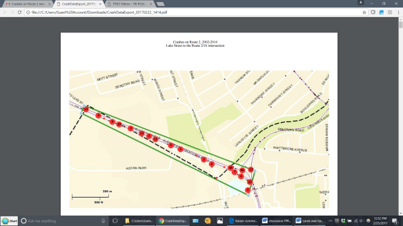
Crashes on Rte. 2, 2002-2014 Source: https://services.massdot.state.ma.us/crashportal/
- Open space and public realm/ Building scale and massing. The developer has been adept at fitting as many units as possible onto the site despite its difficult shape. What is the justification for this density of development when it will result in so many negative impacts and provide housing that is squeezed between parking garages and a highway, with views of adjacent office buildings, garages and the congested highway (with its attendant air pollution) just feet away. This building density has left little room for public amenities or open space that would help to build the sense of community of which this site is devoid. If this site were used for housing, there is no street-level retail shown and people would presumably have to drive to supermarkets offsite to get food and other necessities. The proponent describes the development as an “urban village.” In what way does this development have features of such a village, such as public sphere, shops, playgrounds, etc.? The developer should present a design with lower density and a smaller building footprint.
- Environmental concerns. Is there any toxic contamination of the site—will excavation expose contamination that should be remediated or that might move off-site? Any cars parked within the flood zone will not only be destroyed by flooding, their fluids will leak into the water and contaminate Alewife Brook and surrounding areas. The likelihood of cars being parked during a flood is far higher for residential building than office buildings. What water conservation measures are taken for landscaping—will it require irrigation?
- According to the developer’s TIS study, the development will generate 1,006 daily transit trips. What has the City done to obtain increased transit capacity at Alewife?
- We support the strengthened Pedestrian and Bicycle Connection to Discovery Park described in the Traffic and Parking memo (item #4) and the Transportation Demand Management measures. We support the Transportation Mitigation measures outlined in the memo but the payments suggested should be increased significantly in order to adequately fund these measures now so that the work can proceed without further delay.
- The current use as a bowling alley has been a major community asset for generations. How many of us have been to children’s birthday parties there? Redevelopment in the Alewife should replace this asset with something that also creates community cohesion for the larger Alewife area as well as a particular building’s residents. While the proposed 2-lane bowling may be a nice amenity for the residents, would it be accessible to the public? Will they be welcomed in such a small-scale facility?
- City-wide urban design objectives. The CDD memo notes that the goal is to have Alewife “be a sustainable, resilient, mixed used district with convenient and safe connections within the neighborhood and to the rest of the city, along with amenities that support interaction and social ties among its residents.” (p. 5). This project should have amenities at the street level to provide for the residents’ immediate needs and to enliven the streetscape. These could include small retail such as a dry cleaner, food and convenience stores, etc.
Based on the foregoing we have two additional specific recommendations:
- The CDD be responsible for commissioning and presenting the TIS for each project, funded by the developer, as is done in many other communities. We ask that this be given serious consideration and the relevant policies/zoning rules be so amended.
- The Planning Board request a presentation of the most current version of the Cambridge Climate Change Vulnerability Assessment so that you can see the depth and extent of flooding and the extremity of heat waves expected in the city. This may help the Board see their important role in protecting public health and building resilience. The DPW report states that the buildings would comply with the City’s guidelines and survive flooding, but does not show the severity and breadth of the problems for the people who would live and work there that we will encounter in the future.
Thank you for considering our comments; we look forward to continued discussion. Please don’t hesitate to contact me or other FPRA Board members if you have further questions.

I manage YourArlington.com, a 10-year-old site of news and opinion focusing on Arlington, MA. This neighboring project is of interests to town residents, and I am seeking permission to republishing what has been posted here. Thanks for considering this request. Bob Sprague
LikeLiked by 1 person
Yes, that would be great! Can you also send us relevant information from Arlington? Email freshpondresidents@gmail.com.
LikeLike
Thanks you. Once it’s republished, sometime Sunday, I will tell you where to find it.
LikeLike
The alliance comments have been republished at https://www.yourarlington.com/easyblog/entry/15-environment/2324-alliance-031217 The proximity of this proposed project and the Mugar site in East Arlington connects our communities.
LikeLike
The Cambridge Planning Board’s continued public hearing on the 320-unit rental housing project proposed for 195/211 Concord Tpk (Route 2) has been scheduled for *Tuesday, April 4, 8 pm*, at City Hall Annex, 344 Broadway (corner of Inman).
Here’s a link to CDD’s video of the February 21 initial hearing, which begins at the 1:24 mark.
On Sat, Mar 11, 2017 at 3:34 PM, Fresh Pond Residents Alliance wrote:
> freshpondresidents posted: “The Fresh Pond Residents Alliance provided > these written comments to the Cambridge Planning Board on the proposed new > residential development of 320 units at the Lanes & Games/Gateway Inn > property on March 4, 2017. The first Planning Board Hearing was” >
LikeLike
Other than suggesting a laundromat on the tabooed federally designated “floodway”, this is an excellent analysis of what we are dealing with at Alewife, whether Concord Turnpike (Route 2) or Quadrangle on Concord and furthest point north of Alewife Reservation (115 acres of urban wild). 10 citizen-environmentalists sued the next door hotel- now built- for being on the “floodway” and delayed them via DEP for a year, and brought all of our professionals together with scientific writings and site visits. Now very glad North Cambridge Stabilization Committee will carry the torch and organize folks on this one. This is a Rich McKinnon building for Lanes and Games as you must know. Very nice man and is holding his bridge proposal for leverage to get this one up.
Alewife Envisioning has not caught on yet, I fear. Thanks Mike.
LikeLike
Thanks Alison for writing this letter to the many city and state agencies and non-profits for the Cambridge Alewife Envisioning Committee’s work and for the Working Committees about Alewife to deal with in their design plans and proposals and eventual city permitting steps. Thanks to FPRA for their presentation and hoped for organizing tool.
LikeLike