 Transportation in the neighborhoods of Fresh Pond, and the Alewife-Transportation-Community
These comments were made in response to questions of the Boston Metropolitan Planning Organization (MPO). An MPO is required to spend federal transportation funds. The region of the Boston MPO, generally, is within Route 495.
Earlier, the Boston MPO had invited comments on its Vision, Goals and Objectives for transportation. Our earlier comments, dated November 3, 2014, related to the neighborhoods around Fresh Pond. (See 11/3 comments to MPO)
The comments that follow focus on our neighborhoods and urban mobility: walk, bike, bus, Red Line, and commuter rail. We do not ignore motor vehicles. We suggest Transportation-Community rather than corridor as the focus of mobility. Our Transportation-Community includes Watertown, Belmont, Arlington, and Cambridge. The corridor through our community, limited access highway Route 2, Alewife Brook Parkway, and Fresh Pond Parkway, is both an impediment and an opportunity.
Alison Field-Juma and Arthur Strang participated in this writing. We invite comment on the blog.
Executive Summary:
Over the next decade it is clear that housing units and business space will continue their significant growth in the Alewife-Transportation-Community, putting increasing stress on an already overburdened, and at times completely dysfunctional, transportation system. This Transportation-Community includes Watertown, Belmont, Arlington, and Cambridge. The adjacent, and connected, Charles-River-Transportation-Community includes Newton, Brookline, Boston, and Cambridge.
The rising younger work force is showing a mobility trend toward walking, biking, bus, and rail. We support that trend to promote the mobility necessary for the rising demand for mobility across and within our neighborhoods. To do this, we suggest that intersections favor buses, pedestrians, and bikes, and that bus service be tripled over the next decade.
This is especially important in addressing our problematic intersections. Because the transportation system is largely hub-and-spokes, we suggest attention to providing cross-spoke mobility with lighter and quieter buses. We also believe that an integration of private and public bus services should be considered–perhaps through a cooperation agreement and an app to facilitate access and schedules.
In the following summary, we provide detailed examples from our experience in our neighborhoods. We think this experience may be more generally applicable. We also look to the suggestions of others, more expert than we, and from those of other neighborhoods and Transportation-Communities with different perspectives and different mobility interests.
We do not intend to prescribe specific projects. We do suggest that, for our neighborhoods, the focus of transportation be the larger concept of Transportation-Community, defined below. We would hope that people more experienced would have additional and other specific suggestions and strategies.
Introduction:
We think reliable, direct, safe, and attractive are the important characteristics of mobility. We do not think these characteristics require a focus on cars.
“Sometimes, there are a few too many options [transit for a fee], and none are reliable” (emphasis added) Hannah Reff, 27, Somerville
“Boston’s young adults plentiful, influential—and often burdened”, page A10, Monday 1 December 2014 Boston Globe
The term you (Boston MPO) used, “corridor”, may cover these: the end of limited access highway Route 2 at the Alewife T Station in Cambridge; Alewife Brook Parkway to Route 93; and Fresh Pond Parkway to the Charles River connecting to Soldiers Field Road. Other significant corridors include: The Red Line from Alewife, the Fitchburg commuter rail, and the parkways (Memorial Drive, Soldiers Field Road and Storrow Drive) on both sides of the Charles River. In our community, these corridors are both barriers and opportunities.
The parkway corridors appear to be the joint responsibility and authority of the Department of Conservation and Recreation (DCR) and MassDOT. (We invite comment on the division and the coordination of that authority.)
The opportunities we suggest relate to a view of mobility different than transportation corridor—a view that recognizes the linkages, the barriers, the dynamic movements that extend beyond and across a “corridor.” These opportunities, we hope, offer less costly transportation improvements. In our neighborhoods, within our Transportation-Community, and beyond, these opportunities offer the potential of excellent bus, walking and biking routes, for commuting and work-day mobility. These same improvements offer attractive access to jobs, to education, to residential life, to residential services, including grocery stores, and to all the other good things of life.
The Alewife-Transportation-Community (Alewife):
The Alewife-Transportation-Community, pie shaped, follows the hub and spoke alignment of the major streets through it. This Transportation-Community includes: Watertown, Belmont, Arlington, and Cambridge. Within roughly 5-1/2 miles, this community has many commuters who work in Kendall Square, Harvard Square, and numerous other places.
A study of Kendall Square indicates that most commuters live within 5-1/2 miles. Other similarly sized Transportation-Communities would include, for example, the Charles-River-Transportation-Community: Newton, Brookline, Boston, and Cambridge.
This definition of Alewife-Transportation-Community will be used below to highlight the barriers and opportunities to improved transportation in our neighborhoods around Alewife. In our Transportation-Community, much of the traffic of commuting, both work-related and residential, must cross the Parkways or follow them for a short distance to a destination. As a result, we focus on improvements for cross-parkway transportation, as well as suggestions for the parkway corridors.
Transportation in the broadest sense involves: walking, biking, bus, cars, trucks, subway, rail, and new technologies that make all these modes more efficient, less costly, more timely, and less obtrusive.
Summary of Suggestions:
We believe the following should be considered; this list should not be exclusive.
A) Significantly improve bus crossings of the parkways to reduce the trip time of bus routes.
B) Double or triple bus service in the Alewife-Transportation-Community over the next decade, adding more frequent service, more mid-day service, and more evening service.
C) Add new bus service, flexible for workday movement, e.g., grocery shopping, people working within residential neighborhoods, and recreation. Currently cars are the only means of travelling cross-spoke, such as from Waltham to North Cambridge, and many others. Cross-spoke bus service, using quieter, lower-weight buses would affect neighborhoods less.
D) Consider ways to integrate private bus services, offered by employers, with MBTA Bus service, perhaps through a cooperation agreement and an app.
E) Using the “complete streets” framework, complete safe and attractive paths for walking and biking to markets, schools, parks, playgrounds, boathouses, and the Alewife T, with special attention to critical intersections of the parkways.
F) Calm traffic, especially at parkway intersections, including redesign to favor pedestrians, biking and bus crossings, making them easier to negotiate and more in concert with the residential neighborhood.
G) Manage traffic flow on the parkways to reduce emissions and to favor pedestrians and biking.
H) Clarify the authority and roles over the Parkways between DCR, MassDOT and the City of Cambridge; clarify the enforcement of different federal/state/local definitions of excluded buses and trucks; and define reasonable conditions for permits to allow parkway access to excluded vehicles. (We think the permits should be both legible for and visible to pedestrians.)
I) Issue Senior and Student Charlie Cards by web application or US Mail, or at Community/Senior Centers, or all three–as other city transit systems do.
J) Develop a scenario study for the Alewife-Transportation-Community to evaluate mobility, especially bus service, walking and biking. The scenario study should evaluate the potential effects on our Transportation-Community and other Transportation Communities as a result of the significant transportation projects proposed and being implemented in the much larger pie-shaped area between Route 93 and the Mass Pike. We are aware of nine such projects. We list them later. Such a scenario study may also be appropriate for the Charles-River-Transportation-Community. We hope others would support such a study.
 Issues and Examples:
After each of the four Issues raised below, a parentheses contains the particular suggestions listed in the 11/3 letter from the FPRA.
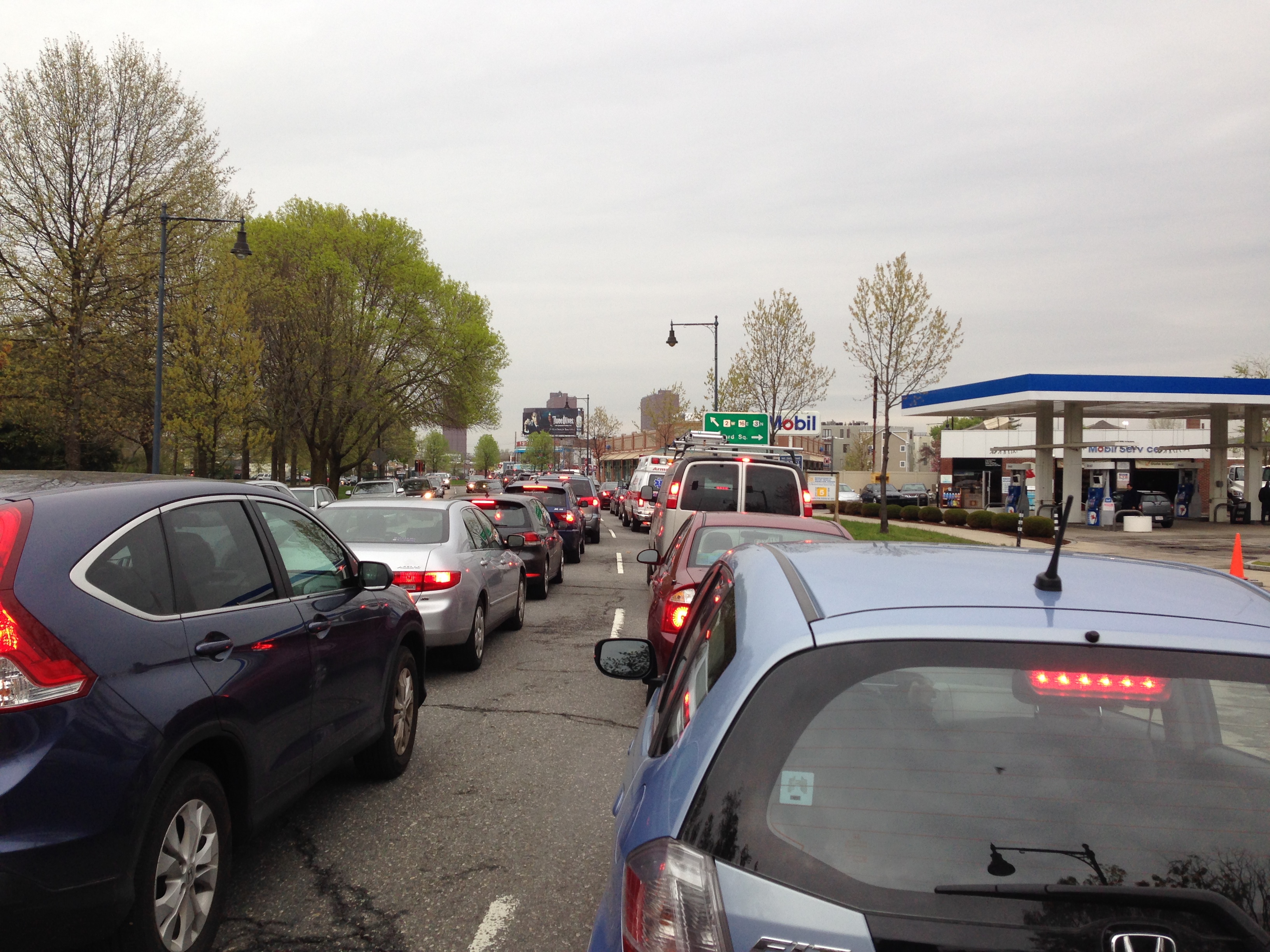
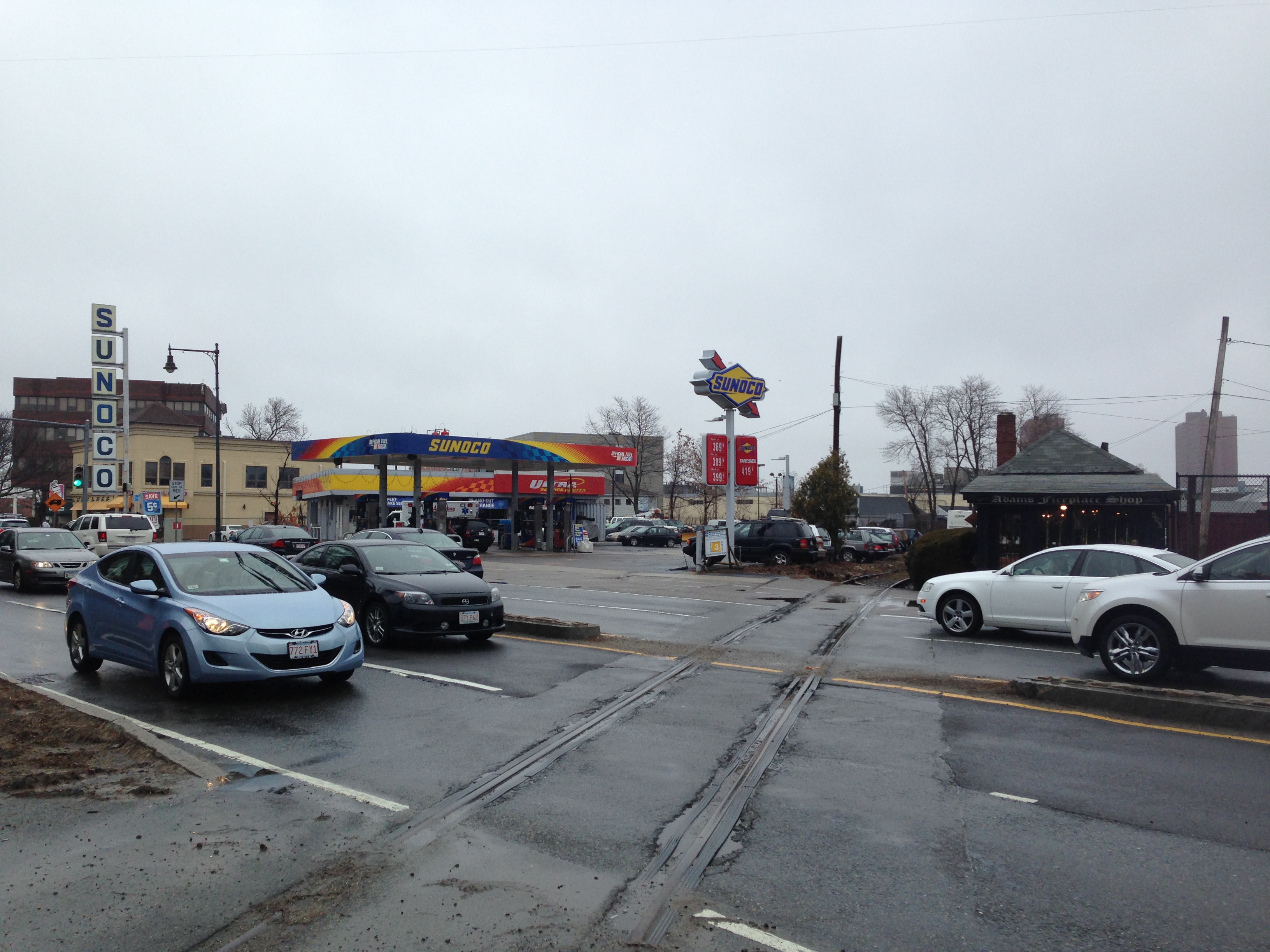
Issue 1: Traffic congestion slows buses at intersections, especially those of Alewife Brook and Fresh Pond Parkways (FPRA #4,5,7,8,11,13,15,16,17,18,19,20)
As an example, consider a resident of Belmont, bringing their child to daycare on their way to work. Taking a bus to the Alewife T or driving into Cambridge and then to work can take an hour on the road or longer. This, for a distance of under 5 1/2 miles.
Transit in general, and commuter bus transit in specific, would be significantly improved by eliminating delays at intersections with the Parkways. Buses should have preference at these intersections. The Parkways include: Routes 2, 3 and 16; and the intersections on Gerry’s Landing Road and at Mount Auburn Street: from the Charles River North to Massachusetts Avenue near the Cambridge/Arlington/Somerville line.
In total, fifteen MBTA bus lines intersect the Parkways on their way to the Red Line at Alewife and Harvard Square and to neighborhoods of jobs and home. All fifteen bus lines are interrupted by the location of the end of limited access highway Route 2, the end of the Red Line at Alewife, and the Parkways.
For example, during the rush hours, four MBTA buses on two Bus Lines (71 and 73) can be seen lined up on Mount Auburn Street near the intersection with Fresh Pond Parkway. We understand that a study will be initiated for the Mount Auburn Street intersection and has been completed for the buses to the Alewife T, to speed their access. We think these studies could include favoring bus services over their entire routes. We also think these studies should look at the full length of the parkway corridor in our transportation community, to coordinate concerted systemic improvements.
Excessive commuting times result in a rising demand for housing inside the constraint of the Parkways. Lower income families are forced to pay significantly more for housing, or they must move. This jeopardizes the human texture of diverse neighborhoods. The attractiveness of living in close-by neighborhoods, such as in neighboring Watertown, Belmont, and Arlington, is also burdened by the lengthy commute. Demand for open space development has reached a critical stage, as has the destruction of the remaining natural habitat.
The growth of jobs at Kendall Square and other places in the Alewife-Transportation-Community suggests substantial growth both in commuting and of intra-day job related mobility. Demand for evening service will increase. Housing demand has risen significantly.
As a result, there is the relevant opportunity to double (or triple) bus transit over the next decade, if it can be made more efficient and neighborhood friendly. To serve specific clientele, new routes might be added during specific hours of day and night, including cross spoke routes, parallel to the parkways.
A strategy should include the private buses, some of which already provide some cross-spoke service. They serve the educational institutions, such as MIT, Harvard and many more. They also serve the employees of companies located in the Alewife-Transportation-Community, employees who commute by bus or who require transportation between workplaces during the day. These same private bus services have routes to Longwood, a significantly growing health and education center, and as far away as businesses on Route 128. These services must cross the barriers of the parkways.
Cross-Town Connect, a public-private transit partnership in west of Boston initiated by the Town of Acton and neighboring towns may be a good model to consider. Their cooperation agreement using their separate door-to-door bus services more effectively can provide the missing link “last mile” bus service to commuters and residents to facilitate transit use.
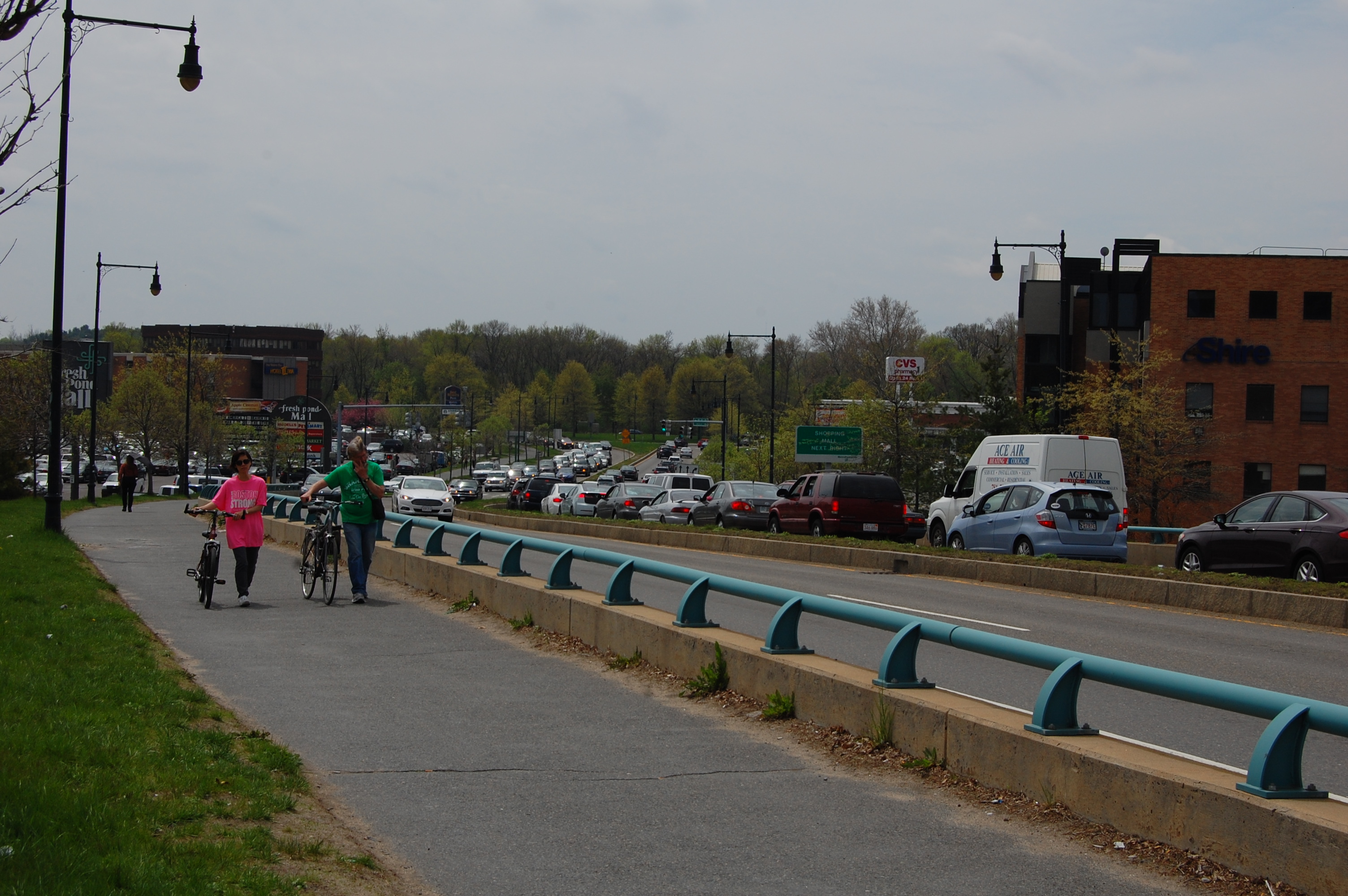
Issue 2: Pedestrians, walking and biking to the Alewife T, grocery stores, parks, the neighbors, schools, and hospitals (FPRA #1,2,3,9,10,12)
Four lanes of rush hour traffic and the close proximity of sidewalks make getting to the Alewife T circuitous, steep, and dangerous, especially through the parking lots of the Fresh Pond Shopping Center. Much of the new housing built, and some of the substantial sites yet to be built, are within a half-mile line-of-sight radius of Alewife T Station. However, significant barriers, including the commuter rail, make the actual walk far longer and far less attractive, and far too dangerous. (See: the pedestrian bridge proposal, the underpass proposal, and the commuter rail stop proposal.)
The only crossing of the commuter rail and the only sidewalks are on the bridge of Alewife Brook Parkway. In traffic, these sidewalks are intimidating to pedestrians and bikers. These relatively narrow sidewalks, with a low barrier, are next to speeding traffic. There is not the substantial safety of the barrier of parked cars, more usual of sidewalks on residential streets.
The bridge of Alewife Brook Parkway is unsafe for school children. The snows and ice of winter are unpredictably cleared from sidewalks, especially for the early morning commuters and school children. The City of Cambridge has decided to bus children who could otherwise walk a safer route. (See: the underpass proposal.)
Within walking distance across the parkways are more than fifteen daycare centers, grade schools, and high schools. For example, the intersection of Mount Auburn Street and Fresh Pond Parkway, including the intersection of Coolidge Hill Avenue, is the crossing for the grade school children of Shady Hill School and the high school students of BB&N. This intersection including that with Coolidge Hill Avenue is controlled by the DCR.
The DCR held public discussions for the rehabilitation of its Lowell Park. The Park is split by Fresh Pond Parkway between Brattle Street and Mount Auburn Street. A wider sidewalk and earlier entry into the Park at the south-west corner of the Brattle Street intersection would be safer for school children and more pedestrian friendly. Equally, a safer redesign of the Coolidge Hill Avenue intersection with Mount Auburn Street would provide a single crossing for school children, rather than the current double crossing. Both intersections are under the control of the DCR.
“Congestion relief has long been a priority for highway spending–it is past time to recognize that addressing congestion is equally important for the transit system [and walking and biking]”. Page 5, ” Hub and Spoke, Core transit congestion and the future of transit and development in greater Boston, The Dukakis Center for Urban and Regional Policy, Northeastern University, June 2012
Within a half mile of the Alewife T and the possible new commuter rail station, in the section called Alewife-North-of-Concord Avenue, there are new apartments, permit applications to build more large residential buildings, and significant vacant land for substantially more residential, commercial and business space.
There should be, but are not, direct, well-built, safe, and attractive paths and sidewalks, and in addition a new way, e.g., a bridge/underpass, over/under the commuter rail. These same paths, yet to be built, would support walking and biking to the multiple markets at the Fresh Pond Shopping Center, attracting nearby residents from their cars. Consider too, a future local bus service passing Star Market on Mount Auburn Street, Fresh Pond Market on Huron Avenue, and the markets at the Fresh Pond Shopping Center, serving neighborhoods along the corridor, South from Massachusetts Avenue at the Arlington/Cambridge/Somerville line to the Charles River.
Concern continues to be expressed about the capacity of mass transit. In the case of Alewife, the capacity of the Red Line requires expansion along its length and especially in the core of Boston. Predictability and frequency need to be improved. The Life Sciences Corridor initiative among the cities and towns along the Red Line corridor promises to attract new businesses to locate near T stations. All this suggests rising use, potentially substantial.
The main entrance to Fresh Pond Park on Fresh Pond Parkway between Poplar road and Lexington Avenue has no walk light. Children of school age can sometimes be seen running across the Parkway to or from the Park.
The Huron Avenue Intersection with Fresh Pond Parkway is another well used access to Fresh Pond Park from the neighborhoods. The intersection witnessed the death of a school child. It regularly witnesses cars running the red light, speeding over 40 MPH, even 50 MPH, in the 30 MPH zone. In addition to regular accidents, reported and not, it witnesses prohibited right turns on red, vehicles stopped on the crosswalks, and prohibited trucks and buses ignoring the multiple signs, all requiring right or left turns off the Parkway inbound.
In contrast, The Riverway near Longwood in Boston has a more appropriate 25 MPH speed limit. Compared with Fresh Pond Parkway, Riverway has curves are less sharp, a longer view ahead, and neighborhoods further removed.
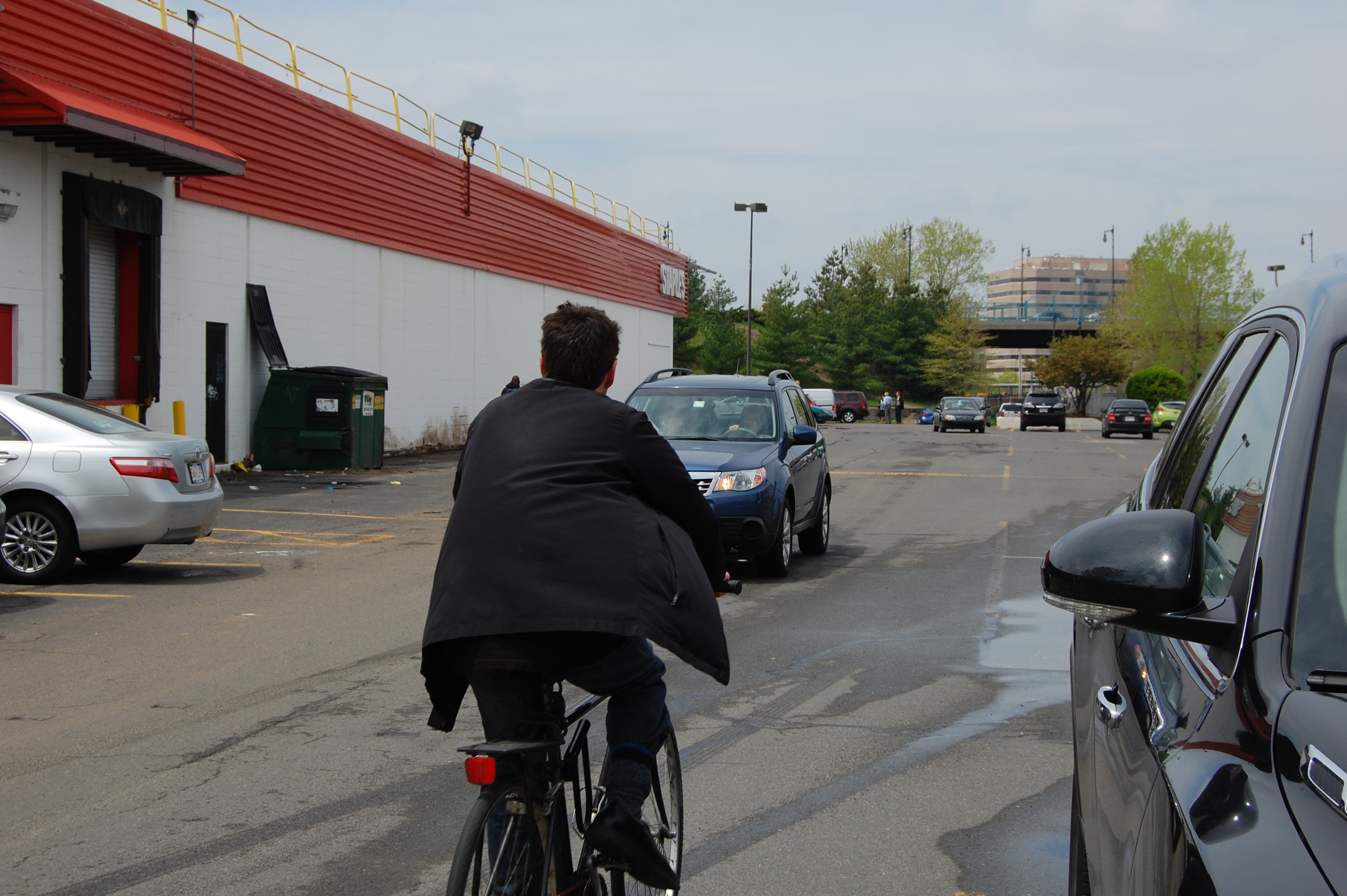
There is an opportunity to close the gap in the bike trail on the parkway corridor from The Minuteman Bike Trail South to the Charles River. Currently biking on the sidewalk is a hazard to would be pedestrians who might otherwise walk rather than drive. Some bikers ride with the traffic of the Parkway even during rush hour, at night, with lights. Admiration comes to mind, as does foolhardy.
The intersections on the parkways that are particularly difficult for bikes are: Gerry’s Landing Road at Memorial Drive, at Greenough Boulevard; at Mount Auburn Street; and at the two rotaries on Concord Avenue. However, none of the intersections on the Parkways are bike friendly or pedestrian friendly. None of them are appropriate intersections for residential neighborhoods.
Issue 3: Pollution and standing traffic during rush hours, use of the Parkways (FPRA #8, and all)
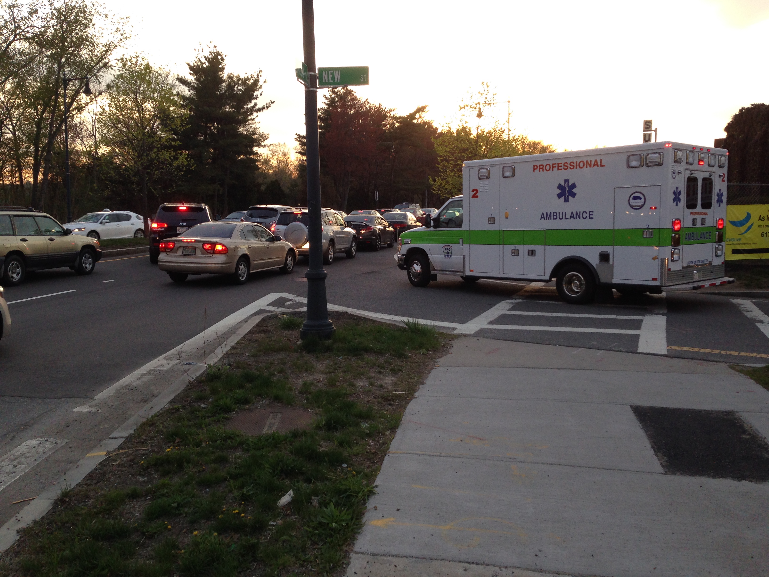
Throughout the rush hour, there is standing traffic on the Parkways next to residences, parks, shopping areas, and rivers. These jams are generally longer than four or five light cycles. Pedestrians bear the brunt of the negative impact on air quality, safety, and attractiveness. Drivers tempted to cut through alternative neighborhood streets are a regular intrusion and danger to nearby residential neighborhoods.
The standing traffic also delays emergency vehicles, especially across and along the Parkways. For example, ambulances headed to, Cambridge City Hospital and Mount Auburn Hospital have to get through the traffic and cross the Parkways. These ambulances come from Watertown, Belmont, and Arlington, as well as from Nevil Center and many other places West of the parkways.
Although trucks and buses are excluded from most of the length of the Parkways, they regularly violate the DCR prohibition (2.5 tons, 7 feet, 12 passengers). There is a difference in the definitions of truck and bus between federal law and the Massachusetts General Law that applies to the Department of Conservation and Recreation (DCR). In apparent violation of DCR restrictions, the former allows more lenient enforcement for larger trucks on the restricted portions of the Parkways.
In addition, the DCR issues permits for trucks and buses for the Parkways. The rules, guidelines, regulations, and purpose for these DCR permits are unclear. These permits should be legible and visible to pedestrians. (We invite comment on the DCR regulations and the specific conditions for issuing such permits.)
“A parkway is not a road, but a park with a road in it.” page 2 under section 1.1 Guiding Principals, Historic Parkway Preservation Treatment Guidelines, Department of Conservation and Recreation (DCR) (March 2007)
Issue 4: Commuting and facilitating cross-spoke transit across neighborhoods (FPRA # all)
While it is vital to the future of all neighborhoods, transit must be many things, including predictable, fast, efficient of time, direct, and for neighborhoods, less obtrusive. This may mean both more buses, and fewer cars. In the Alewife-Transportation-Community, it must mean significantly less bus noise.
Some of our main streets, such as Concord Avenue, are very narrow for such major traffic arteries and residents disproportionately feel and hear the buses as they pass. While better bus service can substitute for cars and sometimes taxis, a reduction of the weight and the noise of buses would better support the neighborhoods through which they travel.
There are many studies suggesting that the speed and predictability of bus transit can attract new ridership. This, we expect is true in the Alewife-Transportation-Community. When the need for cross-spoke transit is addressed, the noise and vibration impacts of public vehicles, such as buses should be corrected.
Finally, we are aware of at least nine significant transportation projects in the larger pie-shape between the Mass Pike to Route 93. These are: on limited access highway-Route 2 (Reformatory Circle, Crosby Corner, intersection at Alewife); Pike Straightening; Everett Casino; Red Line cars & signals; Green Line Extension; Olympics (priority and speed-up of transportation projects); and the Downtown Stadium proposal. All will affect transportation in the Alewife-Transportation-Community.
The cumulative impact of these proposals must be understood, especially the effect on pollution, on mobility, and on the bus service goals for the Alewife-Transportation-Community. A similar, linked scenario study of the Charles-River-Transportation-Community would be illuminating as well for the affect these two transportation communities have on each other.
In conclusion, these thoughts are made from the perspective of the neighborhoods around Fresh Pond and Alewife. Thank you for seeking our input. We hope that our discussion of these issues in some detail will be useful in other neighborhoods and other Transportation-Communities.
We welcome continued dialogue.

When I think about it, there’s plenty of potential to levy a special assessment on development near Alewife, hopefully in exchange for increased density, to pay for some bus/bike/pedestrian bridge over the tracks. Is it to late to levy such a fee? A 45ft bridge (25ft buses 10ft peds 10ft bikes) shouldn’t cost more than 10 million in a sane world.
LikeLike
I’m not sure it makes sense to levy a special assessment that is used to alleviate increased traffic, then go ahead and give a density bonus that adds more traffic. If we want to make any progress, it might be better to just levy the assessment but hold off on the bonus.
LikeLike
Well, an even better solution would be to remove parking requirements to stop government mandated sprawl, but people like to have it both ways and demand low traffic and lots of free parking, so more density and more traffic is the best feasible way to make the area sustainable.
LikeLike
Several hundred thousand dollars have been collected from Alewife developers to study this long talked about bridge, but the city does not own a landing spot in the Quad and the bridge would only be for bikes and pedestrians (not buses or cars) according to the 2005-06 Concord Alewife plan….
LikeLike